
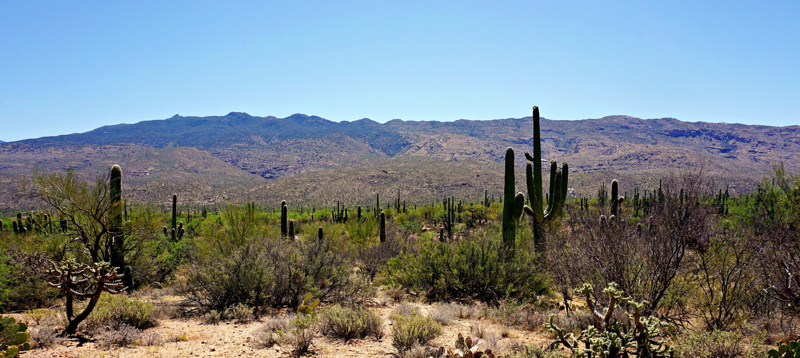
Saguaro National Park has my heart. It’s no secret I’m a desert gal. Maybe because the landscape is so dramatically different from Middle Tennessee.
I’m sure there are desert dwellers who long for the greenery and hills that romanticize my neck of the woods. I hope they see those woods someday. But the desert is my happy place where I can tune out the world and tune into my imagination. And I’ve never been more tuned in than I was in Saguaro National Park.
Table of Contents
Where Is Saguaro National Park?
Saguaro National Park is in Tucson, Arizona, the second largest city in the state (population of over one million) and a close neighbor of Mexico. The border is only 60 miles (98 km) away.
The park is made up of two districts- the Rincon Mountain District (the east side) and the Tucson Mountain District (the west side). The city of Tucson sits smack dab in between.
Why Is the Park Named for a Cactus?
Because saguaros are an important species in the Sonoran Desert ecosystem- very important, actually. Unfortunately, humans can’t be relied upon to protect them without the government getting involved. Well, at least nowadays they can’t. So, it’s a national park.

Saguaro National Park Entry Fee
As of 2026, there have been several updates to the National Park Service entry fees. Please see the National Park Service website for more information.
Note: If you plan on visiting other federal sites with entry fees during the year, you may want to purchase the America the Beautiful Pass. It is good for one calendar year from the date of purchase.
Best Time to Visit
October-May. That’s when temperatures are most tolerable. Summer is not ideal, because temperatures are often over 100 degrees Fahrenheit (38 degrees Celsius). And it doesn’t matter if it’s dry heat or not. Heat is heat and it can kill you. Limit outdoor activities to morning and evening if visiting during summer months.
I was lucky to be in Saguaro National Park in the middle of saguaro bloom season (late April-June) making the scenery even more beautiful. May was a great time to visit the park!

Always Have Water!
Never visit Saguaro National Park without having a sufficient supply of water. Dehydration can occur quickly in a desert. Don’t wait to drink when you get thirsty. Stay continually hydrated. It is recommended that each person have at least 1 gallon of water per person per day.
There are no bottle filling stations anywhere but the visitor centers. Before you head out to explore, know where bottle-filling stations are located and fill up every time you’re near one.
To stay hands-free, consider using a hydration pack. If you’re looking for awesome performers, I recommend Osprey’s Hydraulics Reservoir.
Get to Know the Saguaro
How Do You Pronounce It?
Saguaro is pronounced “suh-wah-roe”. That’s the best way I can explain it without all those crazy phonetic symbols. Here’s how I say it and no one’s made fun of me yet. Learn to say it properly before you visit, especially if you’re planning on making a YouTube video. Please.
Saguaro Basics
Even if you don’t know a saguaro from a hole in the ground, I know you’ve seen them. The saguaro is the iconic cactus of the American West. But to find them, you’ll have to go to the West’s deepest south- the Sonoran Desert stretching from southwest Arizona to southeast California, and down into northwest Mexico.
No, saguaros are NOT native to the Grand Canyon and Monument Valley no matter how many t-shirt retailers tell you they are.

These suckers are big with full-grown saguaros ranging from 40-60 feet (12 m). But it takes them about 100 years to mature, and then they can live another 100 years!
A mature saguaro can top out between 3,000-4,800 pounds (1,361-2,177 kg) with water making up half of its weight. How is it possible to retain that much water? Look at their “skin”. Those accordion-like ridges expand and contract as water increases and decreases. Kind of like my stretchy pants.
Saguaro Spines

What you need to know before you go is the spines are very sharp. Look all you want, but don’t touch! If you get a prick, it hurts. Trust me, you’ll want to carry a pair of tweezers in your backpack just in case.
Saguaro Arms
So, what’s up with the arms? Saguaros can grow arms, but not all of them do. The arms give saguaros unique and often humorous personalities.


Let’s Visit Saguaro!
As I already mentioned, there are two districts of Saguaro National Park- the Rincon Mountain District and the Tucson Mountain District. I suggest visiting both sides even if you only have time for the scenic drives.
We were in the park for 3 full days, so we had ample time to get a taste of both. Here are a few of my favorite memories from each.
Rincon Mountain District
The Rincon Mountain District makes up the east side of Saguaro National Park and although you’re still really close to civilization, the east side feels remote. And that’s exactly why a lot of folks love it.
If you want to avoid crowds and have more quiet time on the trails, make visiting the Rincon Mountain District a priority.
You’ll see a lot of saguaros on this side of the park, but the largest concentration of them is in the Tucson Mountain District.

Cactus Forest Drive
This 8-mile (12.9 km), paved, one-way loop is the only road through the park’s Rincon Mountain District. Even if you’re not planning on hiking, you’ll want to take time to do the Cactus Forest Drive. And it will take some time- if you do it right. The speed limit is only 15 miles/hour. Don’t rush it. And get out of your vehicle, for heaven’s sake! Let yourself feel the desert.
Cactus Forest Drive begins at the Rincon Mountain Visitor Center. Stop in the visitor center first for a map so you’ll know what you’re looking at and where the pull-outs are along the road.
Once you’re on Cactus Forest Drive, you might wonder, “Where’s the forest?”
You’re in it.
I don’t know about yours, but my definition of “forest” did not jive with what we saw. Because most of the plants are short, it’s hard to wrap your mind around this being a forest but botanically speaking, it is.

We couldn’t wait to start hiking and do some Sonoran explorin’! First up on my list of favorite trails in the Rincon District is the Ridgeview.
Ridgeview Trail
The Ridgeview Trail begins at the Loma Alta trailhead. To get to the Loma Alta trailhead, you must drive to the small parking lot at the end of South Camino Loma Alta Road. This road is not on the Cactus Loop Drive. See the map below for directions.
Ridgeview Trail Stats
- Distance: 2.2 miles (3.5 km) round-trip
- Level of Difficulty: Easy/Moderate
- Elevation Gain: 300 feet (91 m)
We hiked Ridgeview Trail during the week in late afternoon, and only one other car was parked in the lot. Considering the Ridgeview is a top spot for watching sunsets, I was surprised the trail wasn’t crowded.
Hiking the Ridgeview is like walking onto a John Wayne movie set. I kept expecting a lonesome cowboy to ride up any minute. We had the trail to ourselves, and I’ll admit it was a little unsettling at first.
The weight of solitude in a vast landscape can feel overwhelming if you aren’t used to it. Once I relaxed into the trail though, I realized this kind of solitude is exactly what I need every now and then. I think all humans do. We’re just too busy to realize it.

The view of the valley and mountains from atop the ridge is worth the steep-ish climb at the end. If you want a sweet spot to watch the sunset, you found one. But it’s not the only one. I’ve got another good one for you.
If you aren’t up for hiking the Ridgeview at sunset, you may want to check out Javelina Rocks instead.
Javelina Rocks Overlook
There’s no better way to end a day in Tucson than watching a grand Arizona sunset and it’s no secret that Javelina Rocks gives you one of the best seats in the house. There is a fairly small parking area about 6 miles (9.7 km) from the beginning of Cactus Forest Drive.
Although it’s called an overlook, you actually have to do a bit of rock scrambling to get to it. Nothing too crazy but keep your abilities in mind.
Arrive at least 45 minutes to an hour early to have the best chance of getting a parking space at the trailhead. We arrived about 1.5 hours before sunset and easily found a spot, but the crowd showed up not long afterward.

Before heading up to the rocks, we wandered around Cactus Forest Drive to take photos. You can get some great shots in the early evening light.
Don’t wait too long to claim your spot on the overlook. Expect to share the rocks with a lot of other people and be happy if you don’t. We were hoping we could get to the edge of a particular rock for an unobstructed view across the desert. Alas, a man had staked his claim on our rock by the time we got there.
The man appeared to be a professional photographer judging from his pile of equipment. Not wanting to crowd him, we waited to see if he might move. He didn’t. After a few minutes, he noticed us eyeing him (like vultures, we were) and invited us to join him.
As it turned out, he was a local television newscaster who had recently moved to Tucson. His new passion was taking photographs in Saguaro National Park. He gave us some pointers on setting up our camera and I was so grateful! He helped me capture one of the most gorgeous sunsets I’d ever seen.

Check out Saguaro National Park’s website for a list of other trails and overlooks located in the Rincon Mountain District. Besides the Ridgeview Trail and Javelina Rocks, we also enjoyed the Desert Ecology Trail– .25 miles (.4 km) and the Mica View/Cactus Forest/Javelina Wash loop- 1-mile (1.6 km) beginning at the Mica View Picnic Area. Both of these trails are accessed from Cactus Forest Drive.

We spent a total of about seven hours in the Rincon Mountain District including a stop at the visitor center, stopping at pull-outs along the Cactus Forest Loop Drive, hiking the trails, picnicking, and watching the sunset at Javelina Rocks. Keep in mind we were at Javelina Rocks for a good 2.5 hours. We took a break mid-afternoon to go back to our rental to cook an early dinner.
Where was our rental? You’ll have to go to my post Tanque Verde- How I Sucked It Up to find out.
Tucson Mountain District
Now, let’s take a look at the west side of Saguaro National Park.

Bajada Loop Drive
This 6-mile (9.7 km), one-way loop road gives you a convenient way to get an overview of the Tucson Mountain District. It’s a dirt road with a 10 mi/hour speed limit. That’s okay, because there are numerous pull-outs and trailheads along the route where you’ll want to stop anyway. You’ll also find a few picnic areas, my top pick being the one at the Signal Hill trailhead.
Signal Hill Trail
By far, this was my favorite area in Saguaro National Park for one reason- petroglyphs. If you’ve never seen ancient Native American rock art, please, please, please stop at Signal Hill.
Signal Hill Trail Stats
- Distance: .5 mile (.8 km) round-trip
- Level of Difficulty: Easy (with a few stairs)
- Elevation Gain: 40 feet (.01 km)
A 40-foot (12.1 m) high volcanic rock pile was the canvas for the pre-historic Hohokam people’s art. Estimated to be hundreds to even over a thousand years old, these petroglyphs will leave you wondering what stories they tell. Or are they stories at all? Once you begin looking for them, you’ll see more and then more, and then more.
This is a LOOK, DON’T TOUCH area. Never touch petroglyphs. The oils from our hands cause deterioration of the art. Never add your own art. This place is not about you. And graffiti is illegal.
Learn more about the Hohokam people on the National Park’s website.


Sendero Esperanza to Hugh Norris Trail
There are many trails to choose from in the Tucson Mountain District, but if you are limited on time and have several hikes you’re trying to complete in one day, I recommend hiking the Sendero Esperanza to Hugh Norris Trail.
Sendero Esperanza to Hugh Norris Trail Stats
- Distance: 3.4 miles (5.5 km) round-trip
- Level of Difficulty: Easy/Moderate
- Elevation Gain: 220 feet (67 m)
The first part of this hike is through a dry wash. It feels more like a sandy stroll than a hike. Eventually, you reach the base of the hill/mountain that leads to the top of the ridge the Hugh Norris Trail junction.
We chose to make this an out-and-back hike after reaching the ridge, but you can extend your hike by continuing on the Hugh Norris Trail on to Wasson Peak (the highest point in the Tucson Mountain District) or by completing the Sendero Esperanza Trail.
If you choose to hike the entire Sendero Esperanza Trail, you’ll be hiking 6.4 miles (10.3 km) one-way. Consult the park map.

The view from the ridge was awesome. We found the most uncomfortable spot we could find on the rocks to eat a picnic, but I’ll sacrifice comfort any day for the kind of view we had.
Check for snakes before you sit down and/or climb on rocks!
Desert Discovery Trail
A short flat trail leads you through a planned desert landscape designed to introduce you to the plants that call the Sonoran Desert home. My advice: DO THIS TRAIL FIRST! That way, you can spend the rest of your trip saying, “I know what that is!”
Desert Discovery Trail Stats
- Distance: .5 mile (.8 km)
- Level of Difficulty: Easy/Accessible/Paved
The Desert Discovery Trail is like a desert classroom. I especially liked learning how desert plants relate to each other. Ever heard of a “nurse” plant? In the photo below, an octopus-looking cactus is acting as a nurse to the young saguaro by protecting it from harsh conditions. The nurse gives the saguaro a better chance of survival. How does it know to do that?

What did my husband love most about the Desert Discovery Trail?

Ramadas. Blessed shade! After a long day of hiking in the desert sun, he was ready to call it quits and camp out on the bench. That’s why he can’t tell you anything about nurse plants.
Visiting Saguaro with Kids
Saguaro is a good park to visit with kids because there are so many easy trails. Just make sure to watch kids carefully and let them know that things with spines can cause painful injuries- even the cute little ones.
Encourage kids to check out Saguaro National Park’s Junior Ranger Program. You can pick up Junior Ranger books at visitor centers or download a copy online and print from home. Kids will learn so much about the park and have fun while doing it. When they are finished, they’ll earn a Saguaro National Park Junior Ranger badge. Learn more about the National Park Service’s Junior Ranger Program in my article Junior Rangers Never Get Old.
Think Everything Looks the Same in Saguaro?
Some say yes. Some say no. To each their own opinion.
I think of deserts like white noise. And maybe that’s because the desert can feel monotonous at times. Once my eyes are overstimulated, I lose focus on the desert’s details and get lost in thought.

The desert never fails to unleash my creativity. For instance, while on the Sendero Esperanza Trail in Saguaro National Park, I wrote one of the most meaningful poems I’ve ever written (most meaningful to me, anyway) and began another one called Is Your Love Gone?– a poem inspired by a Tucson sunrise.
Let’s Eat!
Tucson is a haven for foodies. From classy elegance to street corner food trucks, the city has something for everyone and for every budget. Here are some very budget-friendly options in Tucson you may want to try on your trip.
The Screamery

If you like ice cream, you should not pass this place up. There is a reason The Screamery has won the Best Ice Cream in Arizona award numerous times. That reason is Sweet Cream Honeycomb. If I was a multi-millionaire, I’d fly to Tucson on the weekends just to get it. Really, it’s that good.
Of course, there are lots of other flavors, and we tried a few by getting an ice cream flight. This is a great way to prove I’m right about the Sweet Cream Honeycomb. See The Screamery’s website above for directions to the three Tucson locations.
El Guero Canelo

El Guero Canelo is known for its Sonoran hot dogs– a hot dog cradled in a bolillo (crispy outside/soft inside) bun and topped with beans, tomatoes, onions, and peppers. Similar to a chili dog, but way better!
If you aren’t craving a hot dog, El Guero Canelo has lots of other menu options. See El Guero Canelo’s website above for location information.
Le Cave’s Bakery & Donuts

We ordered several donuts from Le Cave’s, and all were tasty, but the mango-filled was off the chain! Why aren’t these in every donut shop? But fair warning…
Get plenty of napkins and don’t eat the mango-filled in your vehicle. My first bite resulted in an explosion of confectioners’ sugar like you wouldn’t believe. The sugar was all over my clothes, my hair, the dashboard, the console- even the air vents!
La Estrella Bakery

La Estrella is the oldest Hispanic bakery in Tucson. For me, Hispanic bakeries are all about the cookies and La Estrella did not disappoint. These multi-colored triangle cookies were worth going back for more.
La Estrella also serves fresh tortillas and breads along with savory empanadas and tamales. See La Estrella’s website above for location information.
Empire Pizza
Known for their New York style pies available whole or by the slice, Empire Pizza is a favorite among locals. One of Empire’s specialties is the elote (Mexican street corn) pizza made with creamy chipotle mayo, roasted corn, and cotija cheese topped with Tajin and cilantro. It was a winner in my book.
Other Points of Interest Near Saguaro National Park
There are so many other places to see and things to near Saguaro National Park, but here are a few I recommend. You can never get bored in Tucson!
Mt. Lemmon Scenic Byway
If you have time, take a drive to the top of Mt. Lemmon via the 25-mile Mt. Lemmon Scenic Byway. Starting at the base of the Santa Catalina Mountains in Tucson, you’ll wind your way up through the Coronado National Forest and be transported to an entirely different ecosystem.
You’ll won’t believe you’re still in southern Arizona! Because of its cooler temperatures and shaded forests, Mt. Lemmon is a playground for locals and visitors looking to beat the heat.


Be sure to stop at Windy Point for excellent views of the city below and notice the hoodoos along the road. Once you get to the top of Mt. Lemmon, there are many hikes you can choose from. We did the Aspen/Marshall Gulch/Arizona Trail loop, an easy/moderate hike featuring a trickling creek, lots of forest critters, lush foliage, and an excellent view of the Coronado National Forest.
San Xavier Del Bac Mission
San Xavier Del Bac Mission is a wonderful example of early Spanish architecture on the west side of Tucson. It’s a nice place to take a mid-day break from Saguaro National Park.
Unfortunately, we couldn’t see the inside of the Mission. There was a restoration project going on and no tours were offered. Still, it was worth taking time to walk around the Mission’s exterior and marvel at its details.
Make sure to visit the gift shop next door. There were lots of high-quality products made by members of the local Tohono O’odham tribe. The leather goods were impressive!

Keep in mind the Mission is on the Tohono O’odham reservation and is still an active Catholic parish so be respectful. Take heed of the “no photos” warnings posted in certain areas of the community. *You are allowed to take photos on the Mission grounds.
See the San Xavier Del Bac Mission’s website above for location, hours of operation, mass schedule, and tour information.
Sabino Canyon Recreation Area
Sabino Canyon Recreation Area is located at the foot of the Santa Catalina Mountains in Tucson. Sabino Canyon is known for its adventurous trails and the only creek in the area that flows all year.
Since this is a federally managed area, the America the Beautiful Pass covers Sabino Canyon’s entry fee. However, the fee for using the shuttle within the canyon is not covered by the federal pass. See Sabino Canyon’s website above for more information.
Chiricahua National Monument
Chiricahua National Monument is 122 miles (196 km) southeast of Tucson roughly 40 minutes from the city of Willcox and it’s definitely worth the drive.
Rumor has it Chiricahua (pronounced “cheery-cah-wah”) National Monument is slated to become a new national park. I suggest you visit before that happens. Once designated a national park, the crowds will no doubt dramatically increase, and the intimate feel of this monument may be diminished.

If you only have a day to spend at Chiricahua, I recommend you hike the Heart of Rocks Trail. See the monument’s website for more information. I will see Chiricahua again. Hopefully before it becomes a national park, but I’ll take it any way I can get it.
I fell in love with Chiricahua. There’s something really special about it. The Apache Indians think so, too. These mountains are part of their treasured homeland, and they inspired me to write my poem Apache Love.
Tombstone
The city of Tombstone is approximately 75 miles (121 km) southeast of Tucson. If you’re a fan of “The Film” (and let’s face it, there is really only one film about Tombstone that counts), you’ll want to make this trip.
I won’t lie to you about Tombstone. When I visited, it wasn’t at all what I expected. But there was a very good reason for that. You can read all about it in my article Tombstone- How to See the Ghost That Isn’t.
Casa Grande Ruins National Monument
Casa Grande Ruins National Monument is located approximately 75 miles (121 km) northwest of Tucson. It’s an easy side trip to/from Phoenix.
Casa Grande Ruins was built between 1300 and 1350 AD and is worth a stop for even those with a vague interest in Southwest architecture. The ruins are free to visit. Check hours of operation on the monument’s website above.

Karchner Caverns State Park
Karchner Caverns State Park is located 58 miles (93 km) southeast of Tucson just off of I-10. The cave tours at Karchner are highly rated, and I love a good cave tour.
I entered an Arizona State Park poetry contest with Karchner Caverns as the theme. Based upon what I’d read about Karchner and my experiences in other caves, I wrote my poem Contrition. AND I WON! My poem was on display in the visitor center for several months.
Saguaro Wrap-Up
A place where words like palo verde, ocotillo, and cholla roll off the tongue and lodge forever in your consciousness, Saguaro National Park is one I’ll never forget.
The desert is my theme song best sung in the key of Saguaro.

I hope I’ve inspired you to put Saguaro National Park on your travel wish list. Hopefully, your experience will be as memorable as mine.
Photo Attribution: Sonoran hot dogs from https://www.flickr.com/photos/accidentalhedonist/, CC BY 2.0 https://creativecommons.org/licenses/by/2.0, via Wikimedia Commons
From the Library

High Tide in Tucson by Barbara Kingsolver is her reminiscence of the time she spent in Tucson and how it shaped her emotional, political, spiritual, creative, and cultural perspectives. Her collection of essays was thought-provoking and made me want to move to the desert even more.
Comments